Çekerek Dam
An important dam, ranked 10th among Türkiye's dams for water storage capacity.
View on map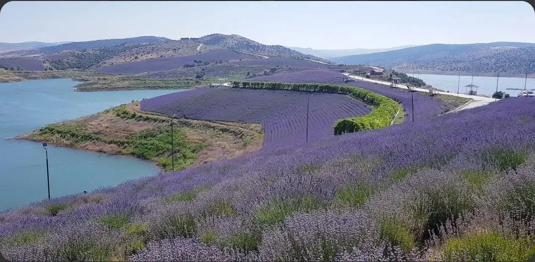 Photo: Emredogan34 (CC BY-SA 4.0) · Source
 5 places to visit in the Çekerek district of Yozgat: Çekerek Dam, Çekerek River and Çekerek Lavender Island. Plan your trip to Çekerek with local food, practical tips and transport information.
Çekerek is a district in the north-east of Yozgat province, 90 km from the provincial centre. It has an area of 790 km² and an average elevation of 942 metres above sea level.
Çekerek was formerly a central village known as Hacıköy and was attached to the Zile district of Tokat. It became the district centre in October 1944, and the Çekerek Stream was given its name. In 1990, Aydıncık and Kadışehri separated from the district to become two new districts.
The district lies in the north-east of the province. It is bordered to the east by Kadışehri and Saraykent, to the south by Sorgun, to the west by Aydıncık, and to the north by Tokat-Zile and Çorum-Ortaköy. The terrain is generally mountainous: the Deveci and Fakı Mountains lie to the east, Alan Mountain to the west and Gebzel Mountain to the south. The mountains are generally steep and rocky, and many caves have formed through erosion and melting in these mountains, which contain a lot of kalken.
The Çekerek Stream, one of the largest rivers in the province and one of the main tributaries of the Yeşilırmak, is the district’s main river. It rises in the Çamlıbel Mountains and enters the district after passing the Deveci Mountains.
The Çekerek area has a transitional climate between the typical continental climate of Central Anatolia and the Black Sea climate. Summers are hot and dry, while winters are cold and rainy.
Farming and livestock form the most important livelihood of the district. As the land is mountainous, there is little arable land, and mostly sheep and goats are raised. Crops such as barley, wheat, chickpeas, lentils, onions and sugar beet are grown mainly on the flatlands along rivers, above all the Çekerek Stream.
The Çekerek Dam ranks 10th among Türkiye’s dams in terms of water collection and capacity. The dam lake is 37 km long, and the width of the embankment reaches 15 km.
In 1944, the Hacıköy sub-district became the district centre. Aydıncık and Kadışehri separated from Çekerek and became districts. At the start of the War of Independence, the Aynacıoğulları staged a revolt in the district. Ali Galip Bey and six officers were killed by the Aynacıoğulları.
Last updated:
An important dam, ranked 10th among Türkiye's dams for water storage capacity.
View on mapOne of the province's largest rivers and one of the main tributaries of the Yeşilırmak.
View on mapA half-island (peninsula) in the Çekerek dam, decorated with lavender seedlings.
View on mapWhile you are in Çekerek, you can also see the highlights of Yozgat province. These places are in other districts; Çekerek is about 90 km from the provincial centre.
A regional dish made with madımak, a wild herb gathered from the Yozgat highlands.
A traditional soup of Yozgat's winter nights.
A district on the Tokat and Çorum border, combining the cultural features of both regions.
The economy is based on farming and livestock.
Çekerek is 90 km from Yozgat city centre. The district borders Tokat's Zile district and Çorum's Ortaköy district.
The 5 highlights of Çekerek: Çekerek Dam, Çekerek River, Çekerek Lavender Island, Çekerek Martyrs' Monument and Çekerek Rafting Course.
Madımak and Arabaşı Çorbası are the signature flavours on Çekerek tables.
Çekerek is known for cereals and its Transitional Culture. Cereal farming is carried out on the Kümbet, Kadışehri and Koyunculu plains.
Çekerek is 90 km from Yozgat city centre. The district borders Tokat's Zile district and Çorum's Ortaköy district.
Suggested visit time: half a day. Best time to visit: spring and summer.