Adıyaman is home to Mount Nemrut, heir to the Kingdom of Commagene and the setting for one of the most impressive sunrise and sunset views in Türkiye. Together with Arsameia, the Karakuş Tumulus and the Roman Cendere Bridge, the province tells the story of a 2,000-year-old kingdom on a single route.

Share with friends

Last updated:

Places to Visit in Adıyaman

14 places worth seeing in Adıyaman, from historic monuments to natural wonders, grouped by type. Open any of them on the map with a single click.

  • 4 Historic
  • 6 Ancient City
  • 1 Religious
  • 1 Museum
  • 2 Nature

Historic Sites 4

Historic

Kâhta Castle (New Castle)

Rising on the rocky hill opposite Arsameia, the castle was taken from the Byzantines by the Seljuks in 1085 and changed hands often during the Mamluk–Mongol wars. Overlooking the Kâhta Stream valley, it is one of the most photogenic stops on the Commagene route.

View on map
Historic

Cendere Bridge

Built over the Cendere Stream in the name of the Roman emperor Septimius Severus (193–211), his wife and his sons, the bridge is known as the widest arch bridge built by the Romans, with an arch span of 34.2 metres. Of the four columns of the 120-metre bridge, all but the column of Geta, which Caracalla had demolished, are still standing.

View on map
Historic

Adıyaman Castle (Hısn-ı Mansur)

Built by the Umayyad commander Mansur bin Cavane, the castle is the core of Hısn-ı Mansur, the name by which the city was known for centuries. The founding of today's city centre goes back to this castle and the settlement around it.

View on map
Historic

Gerger Castle

Built on steep cliffs near the village of Oymaklı (Nefsi Gerger), south of Gerger, the castle dates from the 2nd century BC. The bridge leading to the entrance has collapsed, so getting inside is difficult, but its position overlooking the Euphrates is impressive.

View on map

Ancient Cities 6

Ancient City

Mount Nemrut

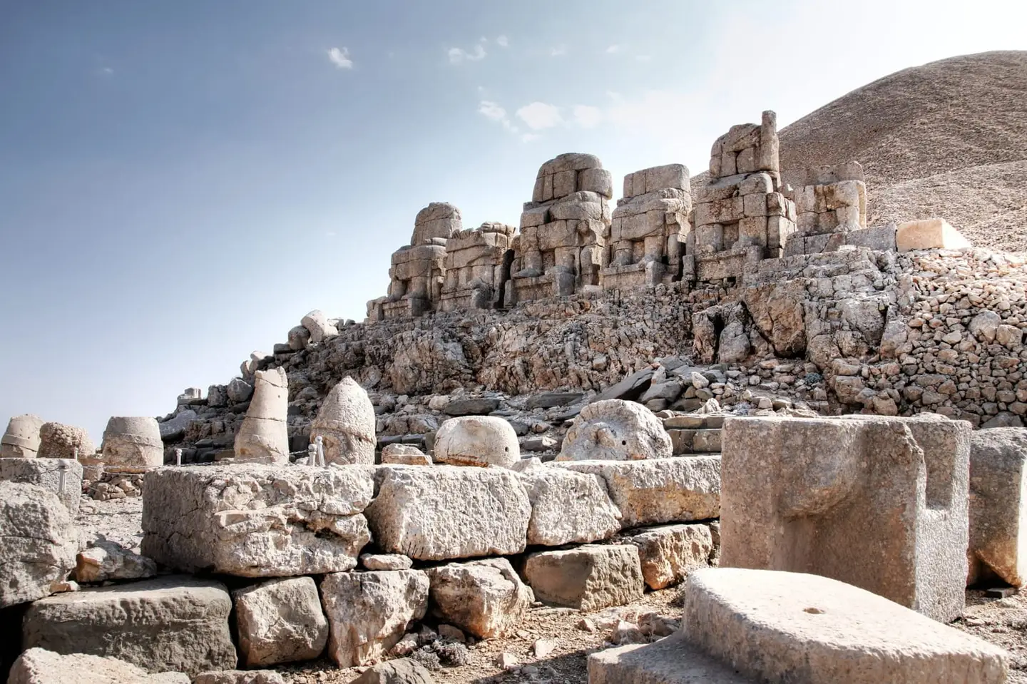
On a 2,150-metre summit at Kâhta, the tomb-sanctuary built by Antiochus I of Commagene in 62 BC, with its giant tumulus of crushed stone and the statues of gods on its east and west terraces, was inscribed on the UNESCO World Heritage List in 1987. The lion horoscope on the west terrace is considered the oldest known horoscope; sunrise is watched from the east terrace and sunset from the west.

View on map
Ancient City

Arsameia (Old Castle)

On the east bank of the Kâhta Stream, 63 km from Adıyaman, Arsameia was one of the important centres of the Commagene royal family. Here you can see the relief of King Mithridates shaking hands with Heracles, the Great Cult Inscription, one of the longest Greek inscriptions in Anatolia, and a 158-metre tunnel carved into the rock.

View on map
Ancient City

Karakuş Tumulus

This monumental tomb on Gösterge Hill, 12 km north of Kâhta, was built for Isias, the mother of King Mithridates II, and for the women of the royal family. It takes its name from the eagle figure on a column; one of the relief columns collapsed in the earthquake of 6 February 2023.

View on map
Ancient City

Sesönk Tumulus

Standing on a high rock at Besni, this tumulus, about 2,060 years old, is a Commagene monumental tomb similar to Karakuş. Beneath the mound, about 7 metres high and 30 metres across, lies a burial chamber with three niches, reached by a flight of steps; it is little visited because there is no access by car.

View on map
Ancient City

Perre Ancient City (Pirin)

Perre, in the Örenli (Pirin) neighbourhood 5 km from the city centre, was one of the five great cities of the Kingdom of Commagene. With its rock-cut tombs and Roman–Byzantine remains, it is the starting point of the Commagene route.

View on map
Ancient City

Palanlı Cave

The cave in the village of Palanlı, in the central district, is estimated to have been used about 40,000 years ago. Together with the excavations at Perre, Haydaran and Turuş, it is among the evidence of Upper Palaeolithic human settlement in the region.

View on map

Religious Buildings 1

Religious

Samsat and the Tomb of Safvan bin Muattal

The remains of Samosata, the capital of Commagene, now lie beneath Lake Atatürk. In Yeni Samsat, the grave of Safvan bin Muattal, a companion of the Prophet who came to the region in the time of Caliph Omar, is one of the province's important places of pilgrimage.

View on map

Museums 1

Museum

Adıyaman Museum

Housed in its building on Atatürk Boulevard since 1982, the museum holds more than 30,000 items, about 1,100 of which are on display. You can see archaeological finds from the Palaeolithic to the Ottoman period, as well as local clothing, jewellery and weaving.

View on map

Natural Wonders 2

Nature

Lake Atatürk

The 817 km² lake of the Atatürk Dam, built between 1983 and 1992, is the third largest lake in Türkiye, and most of it lies within Adıyaman. You can stop on the shores at Samsat and Kâhta for the sunset views.

View on map
Nature

Gölbaşı Lakes

The district of Gölbaşı has three lakes, one in the district centre and two in surrounding villages. The wooded area around the lake in the centre and the Göksu Stream that flows beside it make a green spot for a break in a district at a road junction.

View on map

Getting to Know Adıyaman

Adıyaman lies west of the Euphrates, between the mountains of Malatya, the southern extension of the Taurus Mountains, and Lake Atatürk. Most of the province is in the Southeastern Anatolia Region; part of Çelikhan and Gerger in the north extends into Eastern Anatolia, and part of Gölbaşı and Besni in the west into the Mediterranean Region. With nine districts and an area of 7,644 km², the province is mountainous in the north and made up of broad plains in the south.

Human traces in the region are very old: the cave in the village of Palanlı is estimated to have been used about 40,000 years ago. In these lands, known in antiquity as Kummuh and then as Commagene, the independent Kingdom of Commagene was founded in the 2nd century BC; the capital Samosata (today’s Samsat), Arsameia and Perre were the kingdom’s important cities. The Commagene kings traced their descent from the Persian king Darius I on their father’s side and from Alexander the Great on their mother’s. The most magnificent expression of this claim is the tomb-sanctuary that King Antiochus I built in 62 BC on the 2,150-metre summit of Mount Nemrut. The kingdom was fully annexed by Rome in AD 72.

The origin of today’s city centre goes back to the castle built by the Umayyad commander Mansur bin Cavane; for a long time the city was known as Hısn-ı Mansur, meaning “Mansur’s fortress”, and it officially took the name Adıyaman in 1928. In 1954 it separated from Malatya to become a province.

The earthquake and today: The earthquakes of 6 February 2023, centred on Kahramanmaraş, put Adıyaman among the worst-affected provinces; 8,387 people lost their lives in the city. The historic Grand Mosque was destroyed and one of the relief columns at the Karakuş Tumulus collapsed. Part of the city centre is planned to be moved to safer ground about 6 km away. As rebuilding continues, we recommend checking accommodation and transport information from up-to-date sources before you set out; Mount Nemrut and the Commagene route are still open to visitors.

When to Go

Summers in Adıyaman are very hot and dry, and winters are wet. Averages for 1963–2025 from the Turkish State Meteorological Service:

Month Avg. high Avg. low Rainfall Rainy days
January 8.7 °C 1.5 °C 137 mm 12
February 10.5 °C 2.5 °C 98 mm 12
March 15.1 °C 5.7 °C 91 mm 12
April 20.8 °C 10.0 °C 64 mm 11
May 26.8 °C 14.5 °C 43 mm 9
June 33.4 °C 19.9 °C 8 mm 2
July 38.0 °C 23.9 °C 2 mm 1
August 37.8 °C 23.6 °C 2 mm 0
September 33.2 °C 19.2 °C 8 mm 1
October 25.7 °C 13.9 °C 44 mm 6
November 17.1 °C 7.7 °C 78 mm 9
December 10.9 °C 3.5 °C 134 mm 12

The best time for Nemrut is from late May to October. Thick snow builds up at the summit throughout the winter; the season begins in spring with road-clearing work, and the first visitors often find the summit still covered in snow. The summit is noticeably cooler than the city; even in summer, take a jacket for the sunrise. In July and August temperatures on the plain reach 38 °C (record: 46.3 °C on 15 July 2009); plan daytime outings for early in the morning in these months.

How to Visit Mount Nemrut

On the summit of Nemrut stand a giant tumulus, formed by a heap of crushed stone, and two terraces on its east and west sides. On the terraces are lined up giant statues of Antiochus and his deified ancestors alongside Greek and Persian gods, together with lion and eagle figures; the lion horoscope on the west terrace is considered the oldest known horoscope.

  • Sunrise is watched from the east terrace and sunset from the west terrace. To catch the sunrise you set out from central Adıyaman after midnight (tours usually leave at around 02:30); those staying in Kâhta can leave later.
  • There are two routes: on the Adıyaman side you climb via Kâhta; it is about 43 km from Kâhta to the summit. The road from the Malatya side via Pütürge ends at a point closer to the summit and involves less walking.
  • Those who choose the Kâhta route can see the Karakuş Tumulus, Cendere Bridge, Arsameia and Kâhta (New) Castle on the same day; all of these lie within Mount Nemrut National Park.
  • From the car park you walk to the summit on a stony path; bring comfortable shoes, warm clothing and a torch.

How to Get to Adıyaman

By air: Adıyaman Airport, which opened in 1998, is about 22 km from the city centre; flights connecting to Istanbul and Ankara are operated by Turkish Airlines and AJet. Those who want to climb Nemrut from the Malatya side can also consider Malatya Airport.

By road: Adıyaman lies at the junction of the roads linking Malatya, Kahramanmaraş, Gaziantep and Şanlıurfa. The district of Gölbaşı is the most important point of this junction. For those heading to Nemrut, Kâhta is the hub of the route.

Suggested Itineraries

Day 1 – The Commagene route: Start the morning with the rock tombs of the Perre Ancient City, then move on to Kâhta and visit the Karakuş Tumulus, Cendere Bridge, Arsameia and Kâhta Castle. Watch the sunset on the west terrace of Mount Nemrut and stay overnight in Kâhta.

Day 2 – Sunrise and the Euphrates: Climb to the east terrace for the sunrise (you set out early in the night). After resting on your return, visit Adıyaman Museum in the afternoon; if you like, head towards Samsat and watch the sunset on the shore of Lake Atatürk.

Alternative: The Sesönk Tumulus at Besni and the Gölbaşı lakes are stops along the way for those arriving from the direction of Kahramanmaraş or Gaziantep.

Adıyaman Cuisine

The symbol of Adıyaman is meat-free çiğ köfte: it is made by kneading fine bulgur, isot (dried hot pepper) and spices for a long time, and in 2018 it received a geographical indication under the name “Adıyaman Etsiz Çiğ Köfte”. Şanlıurfa’s objection to the application was rejected because Adıyaman’s registration covers meat-free çiğ köfte only. The seeded Besni grapes of the Besni district, grown for drying, were registered in 2018 with a protected designation of origin; pestil and desserts made from the grapes are also classics of the region. Local flavours such as hıtap and şillik also appear often on Adıyaman tables.

Practical Tips

  • For Nemrut, take a thick jacket, a torch and water; the weather at the summit is much colder than in the city.
  • Because you set out early in the night for the sunrise tour, spending the previous night in Kâhta reduces tiredness.
  • Because rebuilding after the earthquake continues, book accommodation in advance.
  • Places that now lie beneath Lake Atatürk, such as Samosata and Tille Höyük, cannot be visited; in Samsat you can see the grave of Safvan bin Muattal and the view of the lake.
Districts of Adıyaman

Adıyaman province has 9 districts. Explore the places to visit, local dishes and transport in each one.

What to Eat in Adıyaman

All dishes →
  • Adıyaman Etsiz Çiğ Köfte (meat-free raw köfte)

    Meat-free çiğ köfte, made by kneading fine bulgur, isot (dried hot pepper) and spices for a long time, was registered as a protected geographical indication on 12 July 2018; it is served with lettuce and pomegranate molasses.

  • Hıtap (filled griddle pastry)

    An Adıyaman pastry in which a filling is placed inside thinly rolled dough and cooked on a griddle (sac).

  • Şillik (buttered syrup dessert)

    A local dessert prepared by cooking thinly rolled dough and sweetening it with butter and syrup.

  • Besni Üzümü Pestili (Besni grape fruit leather)

    Pestil (fruit leather) made from the molasses of Besni grapes is one of the region's traditional winter preparations.

What to eat in Adıyaman: the full food guide

Adıyaman: Frequently Asked Questions

What are the best places to visit in Adıyaman?

The Commagene route, made up of Mount Nemrut, Arsameia, Kâhta Castle, Cendere Bridge and the Karakuş Tumulus, is the province's most important tourist attraction. To these you can add the Perre Ancient City, Adıyaman Museum, Gerger Castle, Lake Atatürk and the Sesönk Tumulus at Besni.

Where can you watch the sunrise on Mount Nemrut?

Sunrise is watched from the east terrace at the summit and sunset from the west terrace. Sunrise tours from central Adıyaman usually set off at around 02:30 at night.

How do you get to Mount Nemrut?

From the Adıyaman side you go via Kâhta; it is about 43 km from Kâhta to the summit. The road from the Malatya side via Pütürge ends at a point closer to the summit and involves less walking.

What is the best time to visit Mount Nemrut?

The best period is from late May to October. Thick snow builds up at the summit in winter; the season begins in spring with road-clearing work.

What is Adıyaman famous for?

It is known for the giant statues of Mount Nemrut, its meat-free çiğ köfte with a geographical indication, and Besni grapes.

Can you visit Adıyaman after the earthquake?

Yes. The city was heavily damaged in the 2023 earthquakes and rebuilding continues; Mount Nemrut and the Commagene route are still open to visitors. It is advisable to plan accommodation and transport in advance.

More from the Adıyaman Guide

Other Provinces in the Southeastern Anatolia Region

Sources

The information in this guide has been compiled from and checked against the sources below (last checked: 7 October 2026). If you spot an error, please let us know.

  1. Vikipedi – Adıyaman
  2. Vikipedi – Adıyaman (il)
  3. Meteoroloji Genel Müdürlüğü – Adıyaman il istatistikleri (1963–2025)
  4. T.C. Kültür ve Turizm Bakanlığı – Adıyaman
  5. Vikipedi – Nemrut Dağı
  6. Vikipedi – Nemrut Dağı Millî Parkı
  7. Wikipedia – Arsameia
  8. Vikipedi – Kâhta
  9. Vikipedi – Cendere Köprüsü
  10. Vikipedi – Karakuş Tümülüsü
  11. NTV – Adıyaman'da 2 bin 60 yıllık yapı (Sesönk Tümülüsü)
  12. Vikipedi – Perre (antik kent)
  13. Vikipedi – Adıyaman Müzesi
  14. Vikipedi – Adıyaman Ulu Camii
  15. Vikipedi – Gerger Kalesi
  16. Vikipedi – Samsat
  17. Vikipedi – Atatürk Barajı ve Hidroelektrik Santrali
  18. Vikipedi – Gölbaşı, Adıyaman
  19. Vikipedi – Adıyaman Havalimanı
  20. Medyascope – Nemrut sezonun ilk turistlerini karla karşıladı (Nisan 2026)
  21. Pegasus Blog – Nemrut yolunda (gün doğumu turları ve güzergâhlar)
  22. Yolcu360 – Nemrut Dağı gezi rehberi (mesafeler)
  23. Sözcü – Çiğ köfte resmen Adıyaman'a tescillendi
  24. Küre Ansiklopedi – Besni Üzümü
  25. Habergazetesi – Adıyaman ilinin en meşhur şeyleri

Search 81 province guides and 968 district guides.